Local Storage seems to be disabled in your browser.
For the best experience on our site, be sure to turn on Local Storage in your browser.

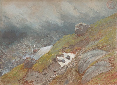
Terrain Near Mont Blanc
In stock
SKU
WMET0204
This Met x Wendover Art Group design is a reproduction of an original work of art in The Metropolitan Museum of Art collection.
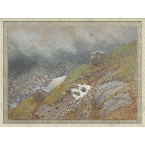
View Above Handeck, Switzerland
Eugène-Emmanuel Viollet-le-Duc (French, 1814–1879)
Watercolor heightened with gouache on blue paper, 10 3/4 x 14 7/8 in., 1875
Purchase, The Isaacson-Draper Foundation Gift, in memory of Jacob Bean, 2018 2018.281
Architect, theorist, and draftsman Viollet-le-Duc spent the last years of his life living in Switzerland, where he worked on the restoration of the Cathedral of Lausanne and on preparing a map of the Mont Blanc massif. The map was published in 1876 with a “study of its geodesic and geological construction, its transformations, and the old and modern state of its glaciers.” Although executed in an area outside the focus of the map, this drawing relates to those made for that project, combining the careful, analytical approach to recording the terrain with a more painterly and evocative use of the watercolor medium.
This Met x Wendover Art Group design is a reproduction of an original work of art in The Metropolitan Museum of Art collection.
View Above Handeck, Switzerland
Eugène-Emmanuel Viollet-le-Duc (French, 1814–1879)
Watercolor heightened with gouache on blue paper, 10 3/4 x 14 7/8 in., 1875
Purchase, The Isaacson-Draper Foundation Gift, in memory of Jacob Bean, 2018 2018.281
Architect, theorist, and draftsman Viollet-le-Duc spent the last years of his life living in Switzerland, where he worked on the restoration of the Cathedral of Lausanne and on preparing a map of the Mont Blanc massif. The map was published in 1876 with a “study of its geodesic and geological construction, its transformations, and the old and modern state of its glaciers.” Although executed in an area outside the focus of the map, this drawing relates to those made for that project, combining the careful, analytical approach to recording the terrain with a more painterly and evocative use of the watercolor medium.